The Fernie Nordic Society maintains the trails at the Elk Valley Nordic Centre and at the Golf Course in partnership with the Fernie Golf Club. The crosscountry ski trails in the region are made possible by the involvement of several land owners, the Fernie Alpine resort, the Fernie Golf Club and the City of Fernie. During the ski season, look for a ski trail map at local sports shops. Visit the great Tourism Fernie website here for more activities to do in Fernie.
Ski in any of these locations within 10 minutes drive from Fernie:
| Nordic Ski Area | Difficulty | Length (km) | Cost | Directions |
|---|---|---|---|---|
| Elk Valley Nordic Centre | Intermediate | 10 | $ | see map |
| Fernie Golf Course | Easy | 8 | $ | see map |
| Fernie Dyke | Easy | 4 | Free | see map |
| Montane | Intermediate | 10 | Free | see map |
| Fernie Alpine Resort | Easy | 9 | Free | see map |
The Elk Valley Pass add-on to the season club membership allows skiers from Fernie to ski on the trails of the local clubs in Sparwood and Elkford. More info and maps may be found HERE.
Elk Valley Nordic Centre
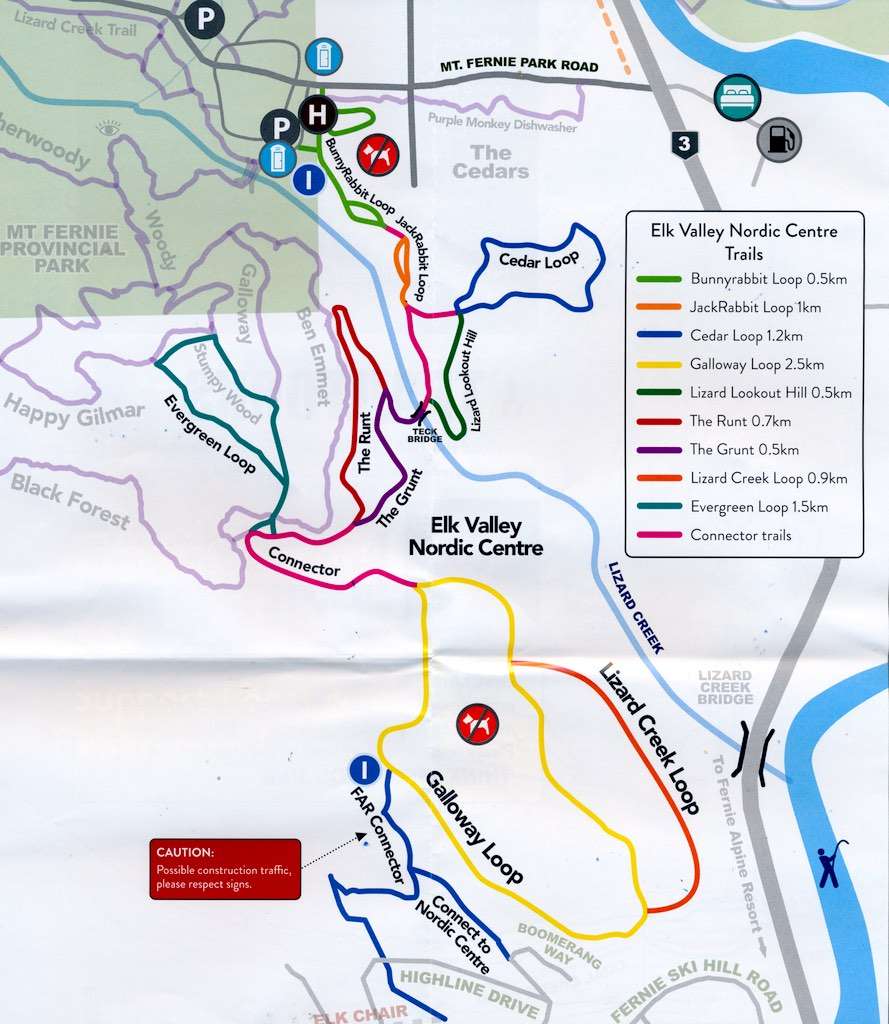
About 10 kilometres of groomed trails are now available for the 2025-2026 ski season. The first trails of the Nordic Centre were set during the fall of 2013. A bridge across the Lizard Creek was installed in November 2014 to give access to additional trails (in purple and yellow on the map). The bypass trail ”The Runt” (in red) was added in the fall of 2015. The Lizard Creek loop is a new short trail running along the Galloway Loop trail.
Curious about our interpretive kiosks? Check this page for the surprising details.
How to get there: To reach the Elk Valley Nordic Centre, go west from Fernie on highway 3. At 3 km from the bridge, turn right at the Island Lake Lodge sign. Follow the road for 0.9 km to the Mt. Fernie Provincial Park sign. Turn left into the overflow parking lot at 0.2 km. The trail head is located on your left about 50 m before the parking lot and it is indicated by a sign. A trail map is posted at the kiosk located in the clearing. Please NO DOGS ON THE TRAILS at any time. Note that more walking trails are located at the far end of the parking lot. Enjoy!
The starting point is the Warming Hut (49.485633 N, 115.090980 W) More trail and elevation info on this page
Access from the Fernie Alpine Resort side:
UPDATE: For the 2025-26 winter, the access is either through Snow Pines Rd and Boomerang Way or from Highline Drive. These multi-use trails connect with the Galloway Loop. Some construction work may happen to close access temporarily.
Map
Fernie Golf Course and Fernie Dyke
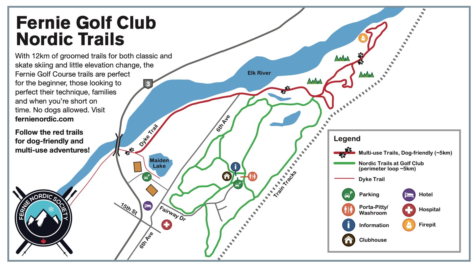
About 8 km of groomed tracks are available on the golf course. There is little change of elevation on these trails so it is optimal for beginner skiers. The start of the trails is at the Clubhouse of the golf course where you will find ample free parking. The trails are jointly groomed by the Golf Course and by the Nordic Society volunteers on a regular basis.
A 4km stretch of the Fernie Dyke is also groomed by the personnel of the golf course. Enjoy the views as you ski on this multi-use trail – Dogs are welcome here.
How to get there: To reach it from the highway 3, turn south at the 13th Street light, then turn left again on 6th Avenue for 400 metres, then right again on Fairway Drive for 800 metres to the parking area.
There is a kiosk next to the Clubhouse for signing up and to deposit your fee for the $15 daily pass or $25 per family, or you may purchase a pass online here. Show your support for our volunteers! You may consider getting a Nordic Society season pass for $100/adult or $220/family here.
The management of the golf course has specified that NO DOGS be allowed on the trails of the golf course.
The starting point is at the clubhouse ( 49.516403 N, 115.047922 W )
More Cross Country ski trails near Fernie
Several easy skiing trails can be found in Fernie and also within a short distance of the city. Just bring some water and snacks for a wonderful time out on the trail. Be aware that other skiers like to enjoy the trails and the great outdoors without having to encounter doggy leftovers. Skiers with dogs are welcome on several trails.
Fernie Alpine Resort
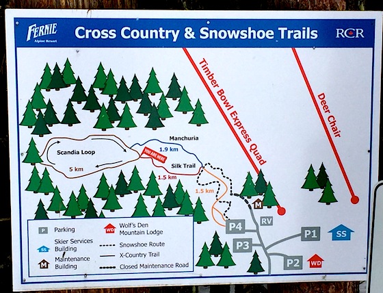
The FAR resort grooms two skiing loops on the southwest side of the resort. The entire course is about 9 km long but it has a bypass at the half-way point. A map of the trail is displayed at the parking lot. This trail is easy but the short section to reach it from the parking lot is steep and a little challenging. Beginners may carry their skis to the start of the loop. Dogs are permitted off-leash on these trails if they are still under ‘vocal command’.
How to get there: From highway 3 west from Fernie, turn right at the FAR sign, about 8 km. Follow the main road keeping to your left at the ski hill buildings until you reach the parking lot #4. The trail starts straight ahead.
The resort does not charge for the use of their trails, but support of the resort businesses is appreciated.
Montane Nordic and Multi-use Trails
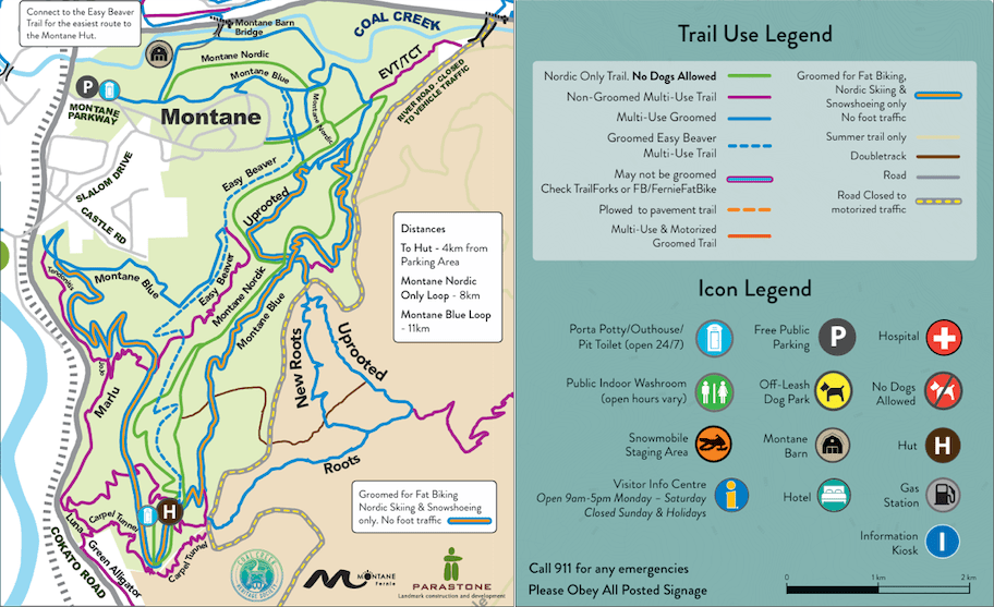
The Coal Creek Heritage Society is doing the trail management and snow grooming on the Montane Property. The trails are now signed and color-coded as follows: all of the road system on Montane Green trail (about 10km) is snowcat groomed and snowmobile groomed for Nordic Skiing Only. For non-motorized multi-use, all of the Montane Blue trail (20 km), Uprooted and Resurrection are available for walkers, dogs, bikers, snowshoers. Also the trail along Coal Creek and the trails close to the Montane housing development are being groomed for multi-use. We have put up one hundred signs showing the routes.
This private land is 3 kilometers long and one kilometer wide, covering the area from Coal Creek to Cokato (Roots Trail Powerline) and below the River Road Extension to Cokato Road. The entire property is signed as non-motorized use. Please follow the signage to respect the trails groomed for nordic skiers.
How to get there: As of summer 2024, the trail head of the network has been moved so access will be from the Pine Ave/Cokato Road area.
More trail and elevation info on this page. The entire Montane property below River Road Extension is non-motorized.